
Midyat, Turkey, Sunday October 18

 Leaving the island, I could have taken a long detour out onto a mountainous peninsula to see a second Armenian church at Altintas, but with the afternoon drawing on, I chose instead to have a pleasant lakeside lunch and then cut across the isthmus of the peninsula on the main road. Little did I suspect that there was a 550-metre climb ahead, over a spur of the Taurus Mountains. As I descended from the pass, the stream I was following suddenly turned south and I realized that it was flowing towards the Tigris river and ancient Mesopotamia; the watershed between Lake Van and the Tigris basin is only a few kilometres inland from Lake Van. I camped at dusk in a dusty field, not far from an encampment of horse-breeding nomads.
 Leaving Bitlis, the road continued its steep descent of the canyon, but the pleasure of the downhill was cancelled by the enormous road construction project that blighted the valley for the next 50 kilometres. It also made it hard to find a campsite. Eventually I spotted something on the other side of the river, and ended up pitching my tent next to a centuries-old caravansaray that is now used as a horse stable by the family whose house sits atop the roof. It was much warmer at this low altitude, and I sat outside the tent gazing at the stars, refreshing my knowledge of the constellations, before retreating to the tent for some guitar. It had been a good day.

 Hasankeyf itself was spectacular, a somewhat modern village near the waterline, below a huge ruined upper city which constitutes one of southeast Turkey's premier attractions. The citadel and upper city are completely uninhabited now, but must have housed a far larger population centuries ago than currently reside in the new town. There are extensive graveyards and mosques (a couple of which must have been Byzantine churches a millenium ago), and many hundreds of stone-built houses. Most of the houses have excavated underground sections, visible now that the soft limestone has weathered away to expose them. I sat atop the highest part of the citadel, watching the afternoon shadows lengthen across this deserted Escher-esque city, photographing and sketching and feeling much happier about being in eastern Turkey. The combination of huge abandoned cityscape and troglodytic houses was like a happy cross between Monemvasia or Mystras (both of which I was lucky enough to visit in Greece last summer) and Turkey's Cappadocia.
 If you ever find yourself in Turkey, you should make room in your itinerary for Hasankeyf before a planned irrigation dam completely submerges the new town and much of the old town, a fate already inflicted on many historic sites in the Euphrates valley further west. That evening I chatted with a Kurdish film-maker now based in the Netherlands about the situation of Kurds in Turkey and in his native Syria. He felt that the Kurds in Syria were far worse off than their ethnic brethren in Turkey, Iraq or Iran.
 Atop the limestone ridges were ancient villages, full of fine stonework, some of which must have been Ottoman and others older, definitely Byzantine and maybe even Roman. I visited three Syrian Orthodox churches: Mor Yakob, Mor Kyriakos and Mor Izozoal. The first was founded in 419, and parts of the stonework in the early basilica-style church seem to date back to that time. I loved the atmosphere of tranquility in the surrounding monastery, and the Aramaic (the language used by Jesus, as well as by the Achaemenid Persian empire as its official language and by Parthian Silk Road traders as a lingua franca during the Roman period) inscriptions. The Aramaic script is interesting, a sort of pointy Arabic strangely similar to Manchu and ancient Mongol. The surrounding village of Baristepe is partly Christian and partly Muslim, with a priest still in residence at the church. Mor Kyriakos, in contrast, is locked up and guarded with a high wall topped with barbed wire. Almost no Christian families still live in the surrounding village of Baglarbasi, most having fled during the Kurdish-Turkish conflict in the 1990s. Mor Izozoal was locked too, but a local Christian family act as caretakers and opened the doors for me. The church has been extensively, and expensively, restored recently, and not as much original architecture is left as at Mor Yakob. I pedalled into Midyat in late afternoon happy with my church-architecture detour, and noted a number of church steeples poking out of the crowded old part of town. The Lonely Planet says that another monastery, Mor Hananyo, south of nearby Mardin, which İ will be visiting in a couple of days, was for many centuries the headquarters of the Syriac Orthodox church, and it seems that the church still puts a fair amount of resources into preserving these historic outposts.
 I rather liked Midyat at first; nobody threw stones at me, and for the first time in Turkey, I had the feeling of being in a modernizing country connected to the rest of the world. Lots of locals chatted with me in a variety of European languages (German, French, Dutch) picked up while working abroad. The whole city had a more relaxed, civilized air than I had encountered further east, with less of an edge of tension, volatility and wildness.

 So what is this corner of Iraq, only 65 km northwest of violent, volatile Mosul, like? The answer is....kind of dull, strangely enough. The main street and the bazaar are crowded with (predominantly male) shoppers, and the town itself is an overgrown village that has grown explosively since the end of the first Iraq war in 1991, and so is lacking in historic buildings although it is in the Tigris valley. I spent my time eating (much tastier, cheaper food than in Turkey), wandering the streets watching the older men, clad in traditional Kurdish overalls, cummerbund and kefiyeh headscarf, about their shopping, and relaxing at my hotel, catching up on rest and sleep after a long stretch of cycling since Yerevan with few rest days.
 So now the final leg of the bicycle journey begins; after spending a lot of time getting to the southern border of Turkey, I will now head more or less directly west along the border, diverting to see historic sites along the way, to Gaziantep, before diverting south to Antakya (ancient Antioch, the third-largest city in the Roman Empire and an endpoint of the early Silk Road) and north to Cilician Armenia and Marco Polo's starting point at Ayas. Within two weeks or so, my eight-month-long traverse of the Silk Road should be over!
Greetings from a mid-size industrial city in SE Turkey where I have just come back from a three-day break from pedalling. More on that later, but first let me bring you up to date on the five days of riding it took to get here from Van.
I left Van early on a sunny day, although there was a definite haziness to the sky. I rode along the lakeshore all the way to the ferry dock for Akdamar Island. I waited around for the required number of tourists (all Turks, except for me) to gather and then we put-putted over to the small rocky island, looking like one of the Cyclades transported magically from the Aegean to eastern Anatolia. 
 The entire region of Van was a major centre of Armenian culture for many centuries until 1915, and the island of Akdamar boasts the most famous single Armenian monument in Turkey, a spectacular church perched atop a ridge, visible from the mainland for many kilometres around. Restored two years ago, the church boasts even more stone carving than I had seen on churches in Armenia itself, with several bands of bas-relief showing a variety of saints and biblical stories. They looked particularly striking in the strong sunlight, and with fresh snow on the high peaks of the Taurus Mountains to the south. I sat and sketched and listened to choral music on the iPod and spent a wonderful hour and a half absorbing the historical and artistic richness of the island.

 The entire region of Van was a major centre of Armenian culture for many centuries until 1915, and the island of Akdamar boasts the most famous single Armenian monument in Turkey, a spectacular church perched atop a ridge, visible from the mainland for many kilometres around. Restored two years ago, the church boasts even more stone carving than I had seen on churches in Armenia itself, with several bands of bas-relief showing a variety of saints and biblical stories. They looked particularly striking in the strong sunlight, and with fresh snow on the high peaks of the Taurus Mountains to the south. I sat and sketched and listened to choral music on the iPod and spent a wonderful hour and a half absorbing the historical and artistic richness of the island.
 Leaving the island, I could have taken a long detour out onto a mountainous peninsula to see a second Armenian church at Altintas, but with the afternoon drawing on, I chose instead to have a pleasant lakeside lunch and then cut across the isthmus of the peninsula on the main road. Little did I suspect that there was a 550-metre climb ahead, over a spur of the Taurus Mountains. As I descended from the pass, the stream I was following suddenly turned south and I realized that it was flowing towards the Tigris river and ancient Mesopotamia; the watershed between Lake Van and the Tigris basin is only a few kilometres inland from Lake Van. I camped at dusk in a dusty field, not far from an encampment of horse-breeding nomads.
The next day I rode, largely inland and out of sight of the lake, to the city of Tatvan, the western terminus of the lake ferries from Van. I climbed up onto the volcanic dam that created Lake Van, had a relaxed lunch and then started a steep drop down the Bitlis River canyon.  I passed through Bitlis, a historic old city founded by one of Alexander the Great's officers and dominated by an ancient castle. I admired a few pieces of fine Seljuk architecture, and then escaped the crowded chaos of the city centre. I had a wonderful moment as I left town. I had chatted briefly with a mailman before I left the kebab shop where I had bought a takeaway doner kebab for dinner. As I pushed my way through the thronged street, a young man came up to me, grabbed my handlebars and demanded money for the privilege of being allowed to go on my way. I had picked up a handy stick beside the road on the way out of Van, and so I pulled it out to convince the lout of the wisdom of letting me proceed unhindered. The youth turned away and started walking quickly back up the street I had descended. Unknown to him, his path led him right past the mail delivery truck in which my mailman friend was sitting, stuck in traffic. As my would-be extortionist came level with the truck, the mailman hopped out of the cab, grabbed the guy in a headlock and delivered a couple of stinging slaps to the head.
  A few passersby, who had seen the entire episode, cheered as the young man ran away, his ears, and head, presumably ringing. I flashed my rescuer a grateful smile and a thumbs up.
 I passed through Bitlis, a historic old city founded by one of Alexander the Great's officers and dominated by an ancient castle. I admired a few pieces of fine Seljuk architecture, and then escaped the crowded chaos of the city centre. I had a wonderful moment as I left town. I had chatted briefly with a mailman before I left the kebab shop where I had bought a takeaway doner kebab for dinner. As I pushed my way through the thronged street, a young man came up to me, grabbed my handlebars and demanded money for the privilege of being allowed to go on my way. I had picked up a handy stick beside the road on the way out of Van, and so I pulled it out to convince the lout of the wisdom of letting me proceed unhindered. The youth turned away and started walking quickly back up the street I had descended. Unknown to him, his path led him right past the mail delivery truck in which my mailman friend was sitting, stuck in traffic. As my would-be extortionist came level with the truck, the mailman hopped out of the cab, grabbed the guy in a headlock and delivered a couple of stinging slaps to the head.
  A few passersby, who had seen the entire episode, cheered as the young man ran away, his ears, and head, presumably ringing. I flashed my rescuer a grateful smile and a thumbs up.
 Leaving Bitlis, the road continued its steep descent of the canyon, but the pleasure of the downhill was cancelled by the enormous road construction project that blighted the valley for the next 50 kilometres. It also made it hard to find a campsite. Eventually I spotted something on the other side of the river, and ended up pitching my tent next to a centuries-old caravansaray that is now used as a horse stable by the family whose house sits atop the roof. It was much warmer at this low altitude, and I sat outside the tent gazing at the stars, refreshing my knowledge of the constellations, before retreating to the tent for some guitar. It had been a good day.
On October 13th, I sped downhill along the river, turned away from the main road to Diyarbakir, and made my way to the small junction city of Kurtalan, from where I hoped to make my way by back roads to the historic town of Hasankeyf. 
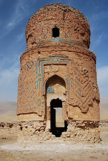 I changed my mind after being advised that the bridge shown on Google Maps didn't really exist and that the Turkish military police, the jandarma, probably wouldn't let me go along this route anyway. The jandarma and the army were particularly thick on the ground in this area, and I have the impression that the area south-east of Bitlis was (and maybe still is) a hotbed of PKK militancy. Certainly the Bitlis River canyon would be a perfect spot to ambush Turkish military convoys. At any rate, I turned east towards the town of Batman (really, that's the name!) and camped about 20 km short of the city, in a landscape utterly transformed since leaving Lake Van. At an elevation of only 700 metres above sea level, I had left the volcanic highlands of eastern Turkey and Armenia definitively behind me and entered Mesopotamia, the once-fertile but now parched lands drained by the Tigris and Euphrates rivers. The sky was hazy with desert dust, and the temperature rose to levels I hadn't felt since Iran. The terrain was now a brown, rolling plateau, bereft of high mountains and less interesting to look at, although easier for cycling. İ was excited, though, as İ really was entering one of the great cradles of ancient civilization, a place even older than the Silk Road itself.

 I changed my mind after being advised that the bridge shown on Google Maps didn't really exist and that the Turkish military police, the jandarma, probably wouldn't let me go along this route anyway. The jandarma and the army were particularly thick on the ground in this area, and I have the impression that the area south-east of Bitlis was (and maybe still is) a hotbed of PKK militancy. Certainly the Bitlis River canyon would be a perfect spot to ambush Turkish military convoys. At any rate, I turned east towards the town of Batman (really, that's the name!) and camped about 20 km short of the city, in a landscape utterly transformed since leaving Lake Van. At an elevation of only 700 metres above sea level, I had left the volcanic highlands of eastern Turkey and Armenia definitively behind me and entered Mesopotamia, the once-fertile but now parched lands drained by the Tigris and Euphrates rivers. The sky was hazy with desert dust, and the temperature rose to levels I hadn't felt since Iran. The terrain was now a brown, rolling plateau, bereft of high mountains and less interesting to look at, although easier for cycling. İ was excited, though, as İ really was entering one of the great cradles of ancient civilization, a place even older than the Silk Road itself.
My last two days into Midyat were easier cycling than usual, and richer in historical and cultural interest than I had become used to. The first day was a short 50-kilometre jaunt into Hasankeyf, a gorgeous old village on the banks of the mighty Tigris River. The ride there was pretty, particularly the last 10 kilometres as I dropped into the Tigris valley, lined on the far bank by steep cliffs pitted with man-made caves; the entire area is rich in troglodyte dwellings.

 Hasankeyf itself was spectacular, a somewhat modern village near the waterline, below a huge ruined upper city which constitutes one of southeast Turkey's premier attractions. The citadel and upper city are completely uninhabited now, but must have housed a far larger population centuries ago than currently reside in the new town. There are extensive graveyards and mosques (a couple of which must have been Byzantine churches a millenium ago), and many hundreds of stone-built houses. Most of the houses have excavated underground sections, visible now that the soft limestone has weathered away to expose them. I sat atop the highest part of the citadel, watching the afternoon shadows lengthen across this deserted Escher-esque city, photographing and sketching and feeling much happier about being in eastern Turkey. The combination of huge abandoned cityscape and troglodytic houses was like a happy cross between Monemvasia or Mystras (both of which I was lucky enough to visit in Greece last summer) and Turkey's Cappadocia.
 If you ever find yourself in Turkey, you should make room in your itinerary for Hasankeyf before a planned irrigation dam completely submerges the new town and much of the old town, a fate already inflicted on many historic sites in the Euphrates valley further west. That evening I chatted with a Kurdish film-maker now based in the Netherlands about the situation of Kurds in Turkey and in his native Syria. He felt that the Kurds in Syria were far worse off than their ethnic brethren in Turkey, Iraq or Iran.
The next morning I was away from my cheap motel by 7:30, an almost unheard-of early departure, and rode back out of the Tigris valley and up onto a picturesque limestone plateau, the Tur Abdin, a historic hotbed of Syriac Orthodox Christianity. I got most of the way to Midyat, and then turned east to explore a few of the historic villages and churches that dot the plateau. I was glad that I did, as I loved the atmosphere of the area. It felt very timeless and Levantine, with old vineyards and olive groves carved painstakingly out of the rocky landscape, the removed chunks of limestone piled into ancient stone walls between fields. There was essentially no motorized transport, with donkeys and horses filling the gap picturesquely. The grape harvest was in full swing, and I was given bunches of grapes to munch on.
 Atop the limestone ridges were ancient villages, full of fine stonework, some of which must have been Ottoman and others older, definitely Byzantine and maybe even Roman. I visited three Syrian Orthodox churches: Mor Yakob, Mor Kyriakos and Mor Izozoal. The first was founded in 419, and parts of the stonework in the early basilica-style church seem to date back to that time. I loved the atmosphere of tranquility in the surrounding monastery, and the Aramaic (the language used by Jesus, as well as by the Achaemenid Persian empire as its official language and by Parthian Silk Road traders as a lingua franca during the Roman period) inscriptions. The Aramaic script is interesting, a sort of pointy Arabic strangely similar to Manchu and ancient Mongol. The surrounding village of Baristepe is partly Christian and partly Muslim, with a priest still in residence at the church. Mor Kyriakos, in contrast, is locked up and guarded with a high wall topped with barbed wire. Almost no Christian families still live in the surrounding village of Baglarbasi, most having fled during the Kurdish-Turkish conflict in the 1990s. Mor Izozoal was locked too, but a local Christian family act as caretakers and opened the doors for me. The church has been extensively, and expensively, restored recently, and not as much original architecture is left as at Mor Yakob. I pedalled into Midyat in late afternoon happy with my church-architecture detour, and noted a number of church steeples poking out of the crowded old part of town. The Lonely Planet says that another monastery, Mor Hananyo, south of nearby Mardin, which İ will be visiting in a couple of days, was for many centuries the headquarters of the Syriac Orthodox church, and it seems that the church still puts a fair amount of resources into preserving these historic outposts.
 I rather liked Midyat at first; nobody threw stones at me, and for the first time in Turkey, I had the feeling of being in a modernizing country connected to the rest of the world. Lots of locals chatted with me in a variety of European languages (German, French, Dutch) picked up while working abroad. The whole city had a more relaxed, civilized air than I had encountered further east, with less of an edge of tension, volatility and wildness.
I left my bicycle and most of my luggage in the hotel on October 16th and headed off on a little excursion to the south and east of town. Being an incurable country-bagger, I saw the opportunity to add an interesting entry stamp to my passport: Iraq. Now, before you, gentle readers, start hyperventilating or writing me off as a deranged lunatic, I should add that I only visited the relatively stable, calm and safe Kurdish autonomous area in the north. Backpackers have been making their way here for several years now, and Tony Wheeler, founder of the Lonely Planet, made a much-publicized visit a few years ago.
It was remarkably easy and straightforward to get from Midyat to the town of Dohuk: a couple of minibuses to the town of Cizre in Turkey, then a shared taxi to the border post, where I got stamped out of Turkey and into Iraq within an hour, unlike the trucks (laden with bags of concrete and other construction supplies) stuck in a ten-kilometre-long queue on both sides of the border. I spent a tedious while both at the border and in the nearby town of Zakho waiting for other passengers to share the cost of a taxi to Dohuk, but I was still in Dohuk before two o'clock, six hours after leaving Midyat.

 So what is this corner of Iraq, only 65 km northwest of violent, volatile Mosul, like? The answer is....kind of dull, strangely enough. The main street and the bazaar are crowded with (predominantly male) shoppers, and the town itself is an overgrown village that has grown explosively since the end of the first Iraq war in 1991, and so is lacking in historic buildings although it is in the Tigris valley. I spent my time eating (much tastier, cheaper food than in Turkey), wandering the streets watching the older men, clad in traditional Kurdish overalls, cummerbund and kefiyeh headscarf, about their shopping, and relaxing at my hotel, catching up on rest and sleep after a long stretch of cycling since Yerevan with few rest days.
Quite a few people speak English or German from time spent abroad, or from working with American forces, and I have had some interesting discussions. I spent an hour drinking tea on a street famous for the trade in birds (ptarmigans, according to an older gentleman with impeccable English, although I suspect they may be another species) and guns (I saw a lot of pistols changing hands for a hundred dollars or so a pop). 
 I watched lots of tennis on TV, and read lots of Shakespeare. Iraq may seem a strange place to come to unwind, but it did the trick for me. I would love to go back to Iraq someday when it's possible to visit the historic monuments further south, but that day looks pretty far in the future at the moment. İronically, on my way back through Turkey to Midyat, İ passed the site of a PKK bombing earlier in the day. Makes me wonder which side of the border is actually more secure!

 I watched lots of tennis on TV, and read lots of Shakespeare. Iraq may seem a strange place to come to unwind, but it did the trick for me. I would love to go back to Iraq someday when it's possible to visit the historic monuments further south, but that day looks pretty far in the future at the moment. İronically, on my way back through Turkey to Midyat, İ passed the site of a PKK bombing earlier in the day. Makes me wonder which side of the border is actually more secure!
My initial liking for Midyat has been dimmed; when İ got back from İraq, İ took a stroll through the old part of town, full of pretty stonework, but had to abandon it as İ was followed by a mob of feral children baying for money and throwing stones (for once, the girls were worse behaved than the boys). One thing that puzzles me about Turkey is that Turks are supposedly crazy about family and children, but then so many parents let their children run wild in Dickensian street mobs without any supervision or discipline. Out here in the east of Turkey, there are an awful lot of kids not going to school from a very young age, hanging around on the street begging for money and cigarettes. It strikes me that by allowing parents not to send 7-year-olds to school, the Turkish government is storing up problems for the future. A large group of uneducated, undisciplined young people with no prospects of employment in a modern economy would be a perfect recruiting ground for the next generation of PKK fighters.
 So now the final leg of the bicycle journey begins; after spending a lot of time getting to the southern border of Turkey, I will now head more or less directly west along the border, diverting to see historic sites along the way, to Gaziantep, before diverting south to Antakya (ancient Antioch, the third-largest city in the Roman Empire and an endpoint of the early Silk Road) and north to Cilician Armenia and Marco Polo's starting point at Ayas. Within two weeks or so, my eight-month-long traverse of the Silk Road should be over!
Peace and (Iraqi) tailwinds.
Riding Day No.
|
Date
|
Distance
From Bushehr
|
Daily
Distance
| Final Elevation |
Vertical
Metres
|
Cycling
Time
|
Average
Speed
|
Maximum
Speed
| Daily Destination |
| 69 | 10/11 | 6237.3 | 101.2 | 1787 | 1072 | 6:20 | 16.0 | 44.7 | near Tonsonlu |
| 70 | 10/12 | 6334.4 | 97.1 | 1065 | 712 | 5:58 | 16.3 | 50.7 | near Narlidere |
| 71 | 10/13 | 6435.8 | 101.4 | 707 | 969 | 6:13 | 16.3 | 66.0 | Besiri |
| 72 | 10/14 | 6487.5 | 51.7 | 438 | 604 | 3:19 | 15.6 | 55.2 | Hasankeyf |
| 73 | 10/15 | 6567.1 | 79.6 | 891 | 1247 | 5:50 | 13.6 | 51.7 | Midyat |


